Tag Archives: 96L

Invest 94L Poised to Become a Tropical Cyclone, Invest 95L and 96L on Opposite Sides of the Atlantic Basin

Tropical Activity for August 21st, 2012

And the tropics continue to remain active. Last week saw the development of Hurricane Gordon (now post-tropical) and Tropical Storm Helene (dissipated inland). To replace these three storms, we have three new threads to investigate, with particular attention being payed to the system in the middle (Invest 94L). Lets get right down to the nitty gritty details.
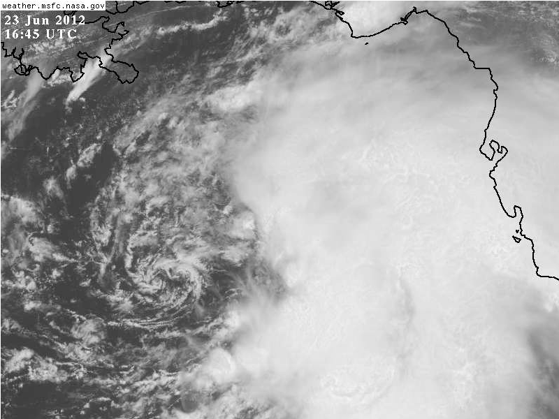

Invest 94L

Infrared animation of Invest 94L

Invest 94L has already been with us for a few days. As a rather potent wave emerging off of Africa, a lot of the guidance developed the system right away, and also took it significantly poleward over the first five days of its expected life. However, this forecast has not panned out, mainly due to the vast majority of models not accounting for the impact of the Saharan Air Layer (SAL) which has both kept the mid-level ridge stronger, forcing a faster westward track, as well as preventing rapid development of this disturbance. Over the past 6 hours, however, the system is starting to consolidate. Deep convection is finally developing close to the disturbance, and microwave imagery had previously shown the system had a well defined surface circulation. More recently, total precipitable water has increased over the system, despite a bit of dry air still trying to advect in from the western side. Shear continues to remain remarkably low over the system, with deep layer easterlies, which bodes well for future development. I agree with the NHC that this system has a near 100% chance of development over the next 48 hours, probably immediately later this morning.

GFS Forecast for Invest 94L. Animated above is the 925 hPa heights (black contours) 500 hPa heights (white contours) and 500 hPa vorticity (color shading).

With the development pretty much expected, where will this system track? At this point most of the guidance takes the system slightly north of due west over the northern Lesser Antilles and into the northern Caribbean Sea. While this seems to be a relatively confident solution, the models have currently handled the track of this disturbance poorly over the last few days. Once again, I think the track guidance might be a little too far north, especially if the system develops more than expected. Case in point, look at the 00z GFS (above). Note that the 500 hPa low center is significantly further south than the low-level center, which is displaced northward. This seems like an unlikely solution in the near term given that the system appears to becoming better vertically coupled. If the storm becomes vertically stacked (where the low and mid level low centers are aligned vertically) then the system will probably slide off further south, given the ENE/WSW orientation of the 500 hPa ridge. This should continue until the system makes it into the Eastern Caribbean. Beyond that period, the track of the system will be dictated on how much the 500 hPa ridge holds in place. The ECWMF keeps the ridge much stronger, which allows for 94L to move further west and stay in the Caribbean, while the GFS is further north, crossing both Hispaniola and Cuba. The track of Invest 94L will also strongly dictate intensity. Intensity guidance is split, with the global models (except for the ECMWF) showing little development, while the statistical models (LGEM, SHIPS) showing robust development over the next five days. I’d be inclined to go with the statistical guidance given the recent trends of a further south track possibly occurring as well improved organization. As always, I’ll keep you guys updated in the days to come if this become a major system.


Invest 95L

Infrared / Visible RGB combo animation of Invest 95L

Invest 95L has been hanging around for the last day near the Mexican coastline. At several points, its pulsed up with convection big time. However, recon flying earlier today was unable to find a well defined enough circulation to classify this system as a tropical cyclone. At this time, it looks like the system is still poorly organized, although convection is increasing. In addition, westerly shear has increased over the system which might limit further development. On the plus side, the system is still over very warm water and high oceanic heat content. In the end, the storm might just be running out of time to develop if it doesn’t do so in the next 24 hours as the system is expect to slowly move east towards the Mexican Coastline. Intensity guidance suggets little development as well, so I am leaning against this system developing over the next 24-48 hours, and I am slightly under the NHC’s 30% probability for development.


Invest 96L

Visible / IR animation combo of Invest 96L

Finally we have Invest 96L. This system emerged off the African coast in the last 48 hours, and already has a broad circulation. Deep convection has been confined to the SW quadrant of the system, but remains vigorous. This system is currently under favorable upper level winds, and decently warm SSTs, which might be able to promote development in the short term. In the long-term, however, upper level winds may become more unfavorable for development. Trackwise, the system is expect to travel west-northwest to northwest over the next few days as the mid-level ridge weakens somewhat over the Central Atlantic.


And that wraps up another tropical weather outlook. Look for more updates in the days to come about Invest 94L which seem poised to become Isaac.

Tropical Storm Debby is Born, A Tricky Track Forecast Remains

Tropical Activity For June 23rd, 2012

And just like that we are off to the fastest start for an Atlantic Hurricane Season ever. Tropical Storm Debby formed this afternoon from Invest 96L which as continued to drift northward and is now located in the East Gulf of Mexico. Debby is the only major player in town, so today’s discussion will focus on the tropical storm. Read all about it below.


Tropical Storm Debby

Visible Animation of Tropical Storm Debby

Tropical Storm Debby still has a very broad circulation that is displaced west of the deepest convection. The visible animation above shows the circulation is comprised of a series of mesovorticies that are rotating around a mean center. This has also been evidence from the recon observations, which have already picked up on two particular centers, one located further to the northeast closer to the deeper convection. With a broad and diffuse center in place currently just outside of the convection, there is some possibility of center relocation if one of the mesovorticies becomes dominant under the deeper convection helping to pull the mean center further east. At this point, the maximum sustained winds are 50 mph and slow strengthening is expected as the storm moves slowly northward over the open waters of the Gulf of Mexico. At this point, Debby is embedded in an environment of high precipitable water, and high Sea Surface Temperatures at 28-29 degrees Celsius. The Oceanic Heat Content is also relatively high. However, the main limiting factor holding Debby back is vertical wind shear, which is out of the south from 20-30 knots. The vertical wind shear is caused by a southwestward moving upper level low, which is located in the western Gulf of Mexico. The shear is likely to continue as long as the upper level low is present.  So where will Debby move to in the coming days, and what areas are under the threat from this tropical cyclone. I’ll have an update later tonight with a track and intensity outlook.

Invest 96L Getting Better Organized, Track Remains Uncertain

Tropical Activity for June 23rd, 2012

The tropics continue to remain unusually active over the past few days, first with Chris turning up the maritime waters in the far North Atlantic, and now Invest 96L which looks to do some water turning of its own as it spins across the Gulf of Mexico. Now that Chris has become a post-tropical disturbance, our attention shifts to 96L which is poised to be the big tropical topic of discussion into the next work week. I’ve got the latest details below.


Invest 96L

Infrared Imagery of Invest 96L

Invest 96L has been taking its sweet time getting organized, the biproduct of a large gyre-like disturbance that organized through a northward progression of the intertropical convergence zone (ITCZ) merging with a disturbance off the Panama coast. Now the feature has been slowly moving northward in the Gulf of Mexico. Don’t let the convection fool you, the center is actually further west in region mainly devoid of convection currently. However, there are individual meosvorticies that are rotating around a larger mean center that are interacting with the convection. The lopsidedness nature of the system is partially due to 20-30 knots of westerly vertical wind shear over the circulation, which is being caused by a upper level trough dropping down from Texas into the Western Gulf of Mexico. This has caused the upper-level anticyclone to be displaced further east of the storm. All of these factors will probably prevent rapid development in the short term, although the system is still gradually getting better organized, and we will likely see tropical cyclogenesis (TCG) sometime in the next 24-48 hours. I am in agreement with the NHC’s assessment that this system has an 80% chance of development in the next 48 hours. With that said, what does the future hold; how strong can 96L get, and where is it going to go?

500 hPa model evolution of both the ECMWF and GFS runs from 00z on 23 June. Plotted are the 500 hPa absolute vorticity (shaded) as well as the geopotential heights (contours). Relevant features are highlighted

Trackwise, things are very much split at this time. This is highlighted in the most recent plot of the model track guidance, showing two main groups taking the system is opposite directions. This difference is highlighted by looking at both the 00z runs of the ECMWF and GFS. The first observation worth noting is that there are not huge differences in the mid-level pattern between each run in the 24-48 hour time frame. The ECMWF does have a touch more ridging in place at 48 hours, but this difference is minor. What is significant though is the estimate position of 96L in both time frames. The ECMWF is distinctly further south and ever so slightly further west. This allows the system to be captured by the easterly flow on the back of an amplifying ridge, which then steers the system westward towards the Texas coastline. The GFS is the polar opposite. The system goes too far north, so the ridge is not able to capture the disturbance fully. Instead, the mid-latitude flow associated with an amplifying trough in the Eastern United States captures the system and the westerly flow associated with the East US trough draws the storm eastward across Florida and then out into the open Atlantic. While these differences are extreme, 96L starts off in very similar positions for the first 24-48 hours, which highlights how key the initial location of this system is. With gyre like circulations such as this, individual mesovortices often can pull a mean center towards that piece of vorticity if the feature is strong enough. Since the convection will likely be focused on the eastern flank of the circulation, there is a decent chance one of those mesovortices could pull the system further east than expected in the short term. This would tend to lend credence to the GFS solution. If the system moves too far northward, it could very well be captured by the amplifying trough that will dig into the east by 72 hours. At this point, its difficult to make a call either way due to the formative nature of this disturbance, but it is likely we will have better agreement by this time tomorrow when the circulation becomes better defined. Thus, for those that have interests in the Gulf of Mexico, stand on guard anywhere from the TX/MX border all the way to the Florida Peninsula. This system simply has not yet decided where it wants to go.

ECWMF Forecast plotting 200 hPa winds (shaded) and heights (contours)

Intensity is also still somewhat up in the air. Most of the intensity guidance is painting very slow intensification, with the statistical guidance being the most bullish calling for a moderate tropical storm. The main reason for the slow intensification trend is the continuation of moderate vertical wind shear, thanks in part to an upper level low that will be rotating to the west of 96L. This will probably limit development for the first 24-48 hours, although this feature is forecast to weaken later in the period. At this point I don’t want to get too caught up into the details, as much of this intensity forecast will be directly linked to the ultimate track this disturbance takes. In the end, the biggest threat remains very heavy rainfall which has already been experienced across the Florida coastline and will likely continue over the next few days.


Thats all I have for the time being as the rest of the tropics are now quiet. I’ll try to give another update on 96L, possibly Debby by tomorrow.

Chris Becomes a Hurricane, Large Disturbance in the Gulf of Mexico (Now Invest 96L)

Tropical Activity for June 21st, 2012

I took an extended break over the past couple of weeks, and now that I’m back the tropics are starting to heat back up despite being relatively early in the season. Tropical Storm Chris which formed yesterday has just been upgraded to the first hurricane of the 2012 hurricane season as it meanders well into the open waters of the north Atlantic. Meanwhile, there is a new disturbance organizing in the Gulf of Mexico which could be a more substancial player in the days to come. Read all about it in this tropical weather update.


Hurricane Chris

Enhanced Infrared Imagery of Hurricane Chris

The hurricane season thus far has proven to be an early bloomer. After recording our first two tropical cyclones of the season in May, the season has continued its early season by providing us with the third named system in June and our first named hurricane, which is much earlier than normal. For a comparison, Irene was the first named hurricane in the 2011 hurricane season, which occurred in late August! In any event, the origin of Chris can actually be traced back to a non-tropical low pressure that developed along a decaying frontal boundary. As the front continued to decay, an upper level potential vorticity (PV) maximum moved over the non-tropical low pressure, and quickly allowed the low pressure to occlude and undergo warm seclusion as it detached from the frontal boundary and became vertically stacked with the upper level disturbance. Deeper convection then began to form around the circulation as the temperature gradient between the marginal sea surface temperatures (SSTs) compared to the anomalously cold upper level temperatures was sufficient for deeper convection. At this point, the system had a decent warm core, and the National Hurricane Center (NHC) felt that the deep convection and overall more tropical nature of the storm was sufficient for an upgrade. Beyond this time, the system has only become better organized, with an eye feature developing on IR as early as last evening. The visible imagery this morning is particularly impressive with spiral bands and moderate deep convection surrounding the eye in all quadrants. Despite the current well organized appearance, the system is quickly moving towards colder waters even less supportive of a tropical cyclone, so its unlikely Chris will be able to continue to intensify as an tropical system. However, there is a 60-70 m/s jet streak located to the west of Chris which is aiding in divergent upper level flow on the left exit region of the jet streak. This will probably allow Chris to transform into a powerful extra-tropical cyclone as it moves over the cooler waters of the north Atlantic.


Gulf of Mexico Disturbance (Now Invest 96L)

Visible Imagery of the Gulf of Mexico Disturbance

With Chris moving out of the picture, the next threat turns to something closer to home that is beginning to organize in the Gulf of Mexico. A very large circulation is developing in the Gulf of Mexico. Currently, we have a broad area of 850 hPa vorticity that is elongated from the Yucatan Peninsula up into the east Gulf of Mexico. This area of vorticity is associated with deep convection, although it is displaced somewhat to the south and east of the vorticity, which is obvious looking at the visible loop above. The convection is also associated with a developing upper level anticyclone, which is helping to ventilate the convection in the upper levels. The biggest questions in the coming days is what will this large broad circulation do, and who will be affected.

ECMWF Forecast for the large-scale circulation that develops over the Gulf of Mexico. Plotted are 500 hPa absolute vorticity (shaded) and geopotential heights (white contours). Annotated features are highlighted.

Animated above is the 00z ECMWF showing absolute vorticity and geopotential heights. I have highlighted the relevant features that will influence the development and track of this feature for the next 5 days. First, I want to draw your attention to the orange shaded areas of cyclonic vorticity. These represent the multiple mesovorticies that are rotating around the larger circulation that is centered over the Gulf of Mexico. While initially these areas of vorticity are small and diffuse, they start to merge over the Eastern Gulf of Mexico east of the mean low level circulation center by day 3. This type of circulation evolution is similar to how tropical cyclones develop in large gyre-like circulations that traditionally occur in the West Pacific Basin. For more reading on these types of cyclones, there are several good papers by Lander (1994) and Molinari and Vollaro (2012) that document the development and evolution of these types of systems. While the gyre circulation is relatively large, it moves very slowly for the first 3-4 days, as the upper level ridge attempts to develop eastward across the deep south in the wake of a weak trough. However, by the end of the forecast period, the upper level ridge gives way, and the westerly flow associated with a series of weak upper level troughs starts to pick up the developing tropical cyclones in the Eastern Gulf of Mexico. A word of caution. While this is one solution depicted from the ECMWF, the forecast genesis of a tropical cyclone (TCG) is still a big unknown. It all depends on which area of vorticity becomes the dominant feature and where these individual mesovorticies decide to merge. The spatial scale of most of the global models is simply too coarse to predict which convective elements will influence the development of this feature. The GFS provides a different solution, with vorticity becoming focused east of the Florida coastline rather than in the Gulf of Mexico. With the potential TCG of this event still a good 2-4 days away, there will probably be large jumps in the modeling, as the models get a better handle of the convective elements rotating around the larger circulation. At this point, there is no done deal that this system will evolve into a tropical cyclone, and I’m in support of the NHC’s outlook of a 30% chance of tropical cyclone development in the next 48 hours. I do think the chances for TCG do increase beyond that time frame, however. Given the broad nature of this disturbance, development will be very slow

GFS forecast at 54 hours with Standardized Anomalies of Precipitable Water (shaded) and 700 hPa winds (wind barbs)

One thing that is probably a safe bet though is torrential rainfall from the Yucatan coastline of Mexico across into Cuba and most of Florida. This circulation will be tapping into a precipitable water environment that is 3-5 standard deviations above average. This moisture originates from moisture originally drawn up from the intertropical convergence zone (ITCZ) that moved northward across Central America after the landfall of Hurricane Carlotta. Thus, while TCG may still be up for debate at this point, the threat for life-threatening flooding rainfall across the large area is a very real concern on the south and eastern regions of this large scale circulation. Even this morning, a sounding from Key West, FL (KKEY) showed total precipitable water at 2.43″ which is near its record value. This is very impressive considering how moist south Florida typically is this time of the year. This very deep and moist atmosphere will only continue to spread northward with time as the low level flow associated with the circulation continues to spread an influx of moisture from Central America northward.


Aside from these two features, there isn’t much else happing, and the East Pacific is quiet after Carlotta hit last week. I’ll keep you updated on the latest in the Gulf of Mexico, and until then enjoy the rest of your work week!

Katia Moving Slowly Northwestward; TD#14 Forms; Invest 96L Forms

Tropical Activity For September 6th, 2011

I sound like a broken record at this point, but the hits keep coming. In addition to Hurricane Katia which is likely to pass in between the United States and Bermuda, we now have a new depression, TD#14. In addition, we also now have Invest 96L which looks likely to become the next system in line to become a tropical cyclone.


Hurricane Katia

Visible Loop of Hurricane Katia

Katia has now been with us for more than a week, but it seems that it is now past its peak. Yesterday, Katia looked very well organized with a large distinct eye surrounded by very deep convection. At that time the storm had 115 knot winds (135 mph). Today, however, this does not seem to be the case, as the storm completes an eyewall replacement cycle (EWRC) which had degraded the appearance of the storm, while also stretching out the radius of maximum sustained winds.  Recon recently made a pass into the storm and found the pressure was actually a bit higher at 962 mb with flight level winds that supported minimal Category 3 intensity. However, SFMR winds were much lower around 80 knots. Thus for a storm undergoing an eyewall replacement cycle, the winds are likely lower than the flight level winds would normally suggest, so the storm has been downgraded to a Category 2 storm with 90 knot (105mph) winds. Trackwise things have become much clearer over the last 24-48 hours, with all of the track guidance showing a sharp turn forecasted to occur between the 48-72 hour period.  Thus, the chances of a United States landfall seem to be very low at this point. Intensity wise, most of the guidance suggest that Katia has peaked and should continue a slow weakening trend over the next 24-48 hours. I have no reason to go against this guidance as conditions will be becoming gradually less favorable as sea surface temperatures decrease and vertical wind shear increases from the southwest. Towards the end of the period the storm will be rapidly accelerating to the northeast and will likely become extra-tropical. I won’t issue a new forecast for this time at this time, but will continue to update the progress of the system as it progresses further north. It looks like the only main threat will be to the shipping lanes rather than any land masses as a tropical cyclone.


Tropical Depression #14

Nighttime Visible Loop of Tropical Depression #14

Hot on the heels of Katia is another Atlantic Basin tropical cyclone. Tropical depression #14 formed this afternoon from a large disturbance associated with a tropical wave that interacted with the inter-tropical convergence zone (ITCZ). The storm looked rather impressive today on visible imagery, with evidence of banding starting to occur around the center. Microwave imagery shows much of the same, although the convective activity still looks a touch disorganized. Shear over the storm currently appears to be around 10-15 knots although a broad anticyclone aloft has persisted over the cyclone. Total precipitable water over the system seems pretty high which should support continued convective development in the short term. The National Hurricane Center is forecasting gradual development of this system into a minimal hurricane by the end of the forecast period in 120 hours as the storm moves mainly on a west-northwest heading. However, I am not in agreement, at least intensity wise.

850mb heights vs. 500mb heights at select time intervals from the 12z ECWMF

First of all, lets look at the track. Here I have compared the 850mb level, which best represents the low level flow that steers shallow systems, with the 500mb level, which represents the mid-level flow that steers more vertically deep systems. Notice that at 24 hours, both the mid-level center and the low-level center of TD#14 are still pretty well stacked, although there is already a bit of separation starting to occur. This separation is due to the low level flow strengthening. Part of the reason why the ECWMF seems to want to intensify the low-level flow may be due to a possible subsident phase of a kelvin wave that is moving through the region over the next 24 hours. A subsident phase of a kelvin wave last week affected Katia in a negative way, creating shear over the system a full 24-48 hours earlier than expected and allowing dry air to advect into the circulation and halt intensification. As the positive outgoing longwave radiation (+OLR) moves over TD#14 it will tend to suppress convective development and allow the low level easterlies to increase in magnitude, hence the stronger low level flow. Thus by 48 hours, the low level circulation as represented at 850mb is running out ahead of the mid-level circulation. This is also obvious at 72 hours. Thus, despite the track guidance showing a path to the west-northwest in agreement with the mid-level flow, I think we will see TD#14 take a more westward path more along with the low-level flow, putting it on the southern end of the track guidance.

200mb wind vectors and magnitude from the 12z ECWMF

Intensity remains tricky as well. While the flow currently over the system seems to be anticyclonic which should promote low shear, the increasing low level flow might cause shear due to the fact that the low level flow might move faster than the upper level flow, even if the wind vector is in the same direction. While most of the intensity guidance points towards a gradually intensifying tropical cyclone over the next 3-5 days, the shear beyond 24 hours might halt strengthening. By 72 hours, the ECWMF is depicting an increasingly unfavorable upper level pattern as a shear axis starts to develop to the north and west of TD#12. Part of this shear axis is caused due to the strong outflow associated with Katia. Overall, this entire setup does not lead me to believe robust development is possible, and I think TD#14 will peak as a weak to moderate tropical storm in the next 24 hours before the shear increases.

My Track and Intensity Forecast For TD#14

Given all of the thoughts above, here is how I think things will play out. TD#14 will likely still intensify modestly in the next 24 hours before the shear gets too strong. However, I’m not expecting more than a weak to moderate tropical storm at best. Beyond 24 hours, the system will gradually weaken and likely maintain a fast west-northwest track as the low level flow steers it further westward than most of the model guidance suggests at this time. There is much uncertainty in the long range beyond 72 hours. The system will likely slow down after it enters the Caribbean, but I don’t know how much will be left of the system by that point. While I have maintained it as a minimal tropical storm at this time frame, the system could easily dissipate beyond 72 hours. It is worth mentioning that the GFS is far more bullish with this system in comparison to the ECWMF. However, looking at the upper level flow, it seems to be unrealistically intensifying TD#14 in the face of pretty strong southerly flow. I’ll keep you guys updated on the latest with this system.


Invest 96L

Visible Loop of Invest 96L

And now we have Invest 96L. This system was declared earlier today after recently organizing a ball of convection and at least a modest circulation. Based on the visible loop above, you can see it still has a ways to come in the organization department. Microwave imagery also looks rather meager at the moment, with not much deep convective elements near the greatest rotation. Despite this, shear is very low over the circulation (5 knots or so) with a well defined anticyclone over the system. This is important, because there is some very dry air in close proximity to the system, and any northerly shear would likely advect this air into the circulation, choking off the convection. However, as long as the shear remains low, this dry air will stay away from the core circulation and we should see further organization. In fact, having such a large area of dry air may prevent the storm from growing too large, allowing for faster genesis as a small circulation. In addition to favorable shear, sea surface temperatures are very warm near the storm, and would support robust development once an inner core is established. With all of these favorable factors identified, its not surprising to see both the GFS and the ECWMF very bullish for development by 48 hours. Thus, I think its very likely this will become our next tropical cyclone, and I am giving Invest 96L a 80% chance of development in the next 48 hours, which is far higher than the NHC’s current probability of 30% in the next 48 hours.


And that’s all I have for this evenings outlook. Check back later this week for another update!