

Tropical Activity For August 25th, 2012
Things continue to remain busy in the Atlantic basin as we have reached the latter half of August. Tropical Storm Isaac (which developed from Invest 94L) is making landfall along the coastline of Haiti, and will be dancing around both Hispaniola and Cuba over the next 24 hours, but seems poised to have a US impact. Meanwhile, Tropical Storm Joyce has degenerated into a trough of low pressure in the Central Atlantic, while there is a new invest (97L) which has emerged off the African coast. Neither of these storms has a substancial threat to develop over the next 24 hours, so my focus will be rightfully on Isaac.
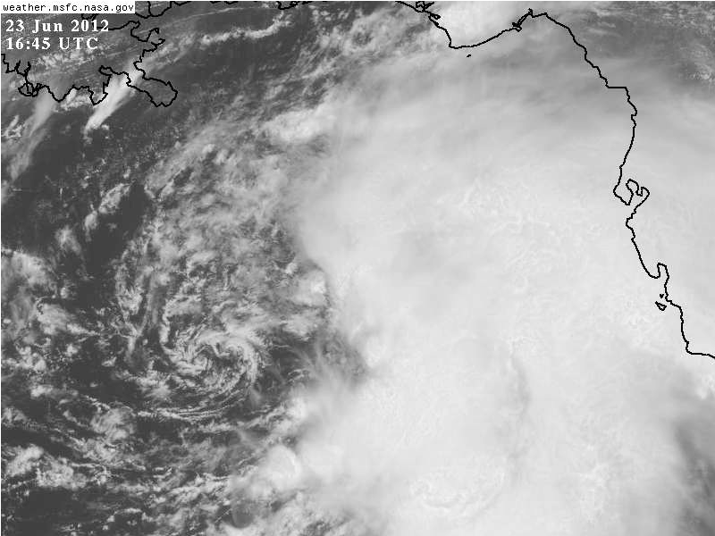
Tropical Storm Isaac

Visible / Infrared Animation of Tropical Storm Isaac
Isaac has been on a tough road the last few days. After becoming a tropical depression earlier in the week, the storm fought bouts of dry air, which prevented the mid-level circulation from aligning with the low-level circulation, hampering development. However, earlier today, the presentation improved substantially as the low and mid-level centers finally aligned. This evening, the convection has organized over the circulation center. As Isaac continues to move further to the northwest, it will interact with the high terrain of Hispaniola and Cuba, but will eventually emerge back over the warm waters south of Florida. Where does Isaac look to be going next, and where in the United States will the impacts be felt? Read below for all the details!

500 hPa forecast comparison for both the ECMWF and GFS. Plotted are heights (white contours), and vorticity (color shading).
Lets first talk about track. Animated above are the 24-96 hour 500 hPa heights and vorticity from both the ECMWF and GFS, two trusted models with a history of accurate tropical cyclone forecasts. Note that early on in the forecast, we have a weakness in place between two mid-level ridges. This is what is causing the NW movement through Haiti currently. However, as this weakness fills back in, the system should bend more to the west-northwest, rounding the northern edge of Cuba. The GFS is a touch faster, but generally both the ECMWF and GFS are in good agreement here. The ridge holds for 24-48 hours, but the ridge overhead of the system is rather thin, which should allow for Isaac to keep gaining significant latitude. By the 96 hour period, the ridge has broken down once again, and a more poleward motion might result before landfall. Overall, with the good agreement beween the ECMWF and the GFS, there is increasing confidence in this solution. Generally this track is supported by the vast majority of the model guidance.

200 hPa forecast comparison of the GFS and ECMWF. Plotted are 200 hPa heights (white contours) 200 hPa wind magnitude (color shading) and direction (vectors).
Taking a look at intensity, there is a little bit of disagreement. While the GFS has a large anticyclone over the system, which would tend to support robust development under low vertical wind shear, the ECMWF is a little bit less favorable, with an upper level low in the Gulf of Mexico initially imparting some southerly shear on Isaac. However, by 72 hours, this feature weakens and retrogrades, so the flow should become more favorable before the final landfall along the Florida panhandle. In addition to favorable shear, the system will be passing over very warm waters, with a good source of oceanic heat content. Much of the intensity forecast also depends on how well developed the inner core is after Isaac emerges off the Cuban coastline in the next 12-24 hours. Overall, the intensity guidance is forecasting intensification, but no models are very agressive, and none indicate rapid intensification. At this point, I am leaning towards the higher side of the guidance with the expectation that Isaac does not weaken too much over land in the short term.

First track forecast for Tropical Storm Isaac
With all of the following discussion, here is my first forecast for Tropical Storm Isaac. I think in the early going the track is likely to be right of most of the guidance owing to the current satellite trends and the fact that the storm is feeling the weakness at its strongest currently. At this weakness in the mid-level flow fills, the storm should bend back to a west-northwest heading from the 24-72 hour period. Finally, the track should once again bend back to the north as the ridge opens up again to the north of Isaac. Intensity wise, I think Isaac will intensify much more than expected owing to the further north forecast in the early going in comparison to the NHC. The storm remains well organized on infrared and I see no reason why it should collapse now that its passed the worst of the high topography. Thus, I’m expecting a strong category 1 hurricane to impact the extreme southern Florida coastline in around 48 hours. The storm should continue to intensify as it gets in the Gulf of Mexico, and I have it peaking at the threshold of category 2/3 intensity in 96 hours. Landfall should occur shortly thereafter between Panama City and Pensacola on the panhandle of Florida. The system will be slowing down at this time, and there is a distinct chance it stalls after making landfall in the Florida Panhandle. Given that these details are still 3-4 days out, there could be some significant changes, although at this time I am reasonably confident in this solution.
That’s all I have time for today. I’ll try to provide another update this weekend.


