

Tropical Activity for June 21st, 2012
I took an extended break over the past couple of weeks, and now that I’m back the tropics are starting to heat back up despite being relatively early in the season. Tropical Storm Chris which formed yesterday has just been upgraded to the first hurricane of the 2012 hurricane season as it meanders well into the open waters of the north Atlantic. Meanwhile, there is a new disturbance organizing in the Gulf of Mexico which could be a more substancial player in the days to come. Read all about it in this tropical weather update.
Hurricane Chris

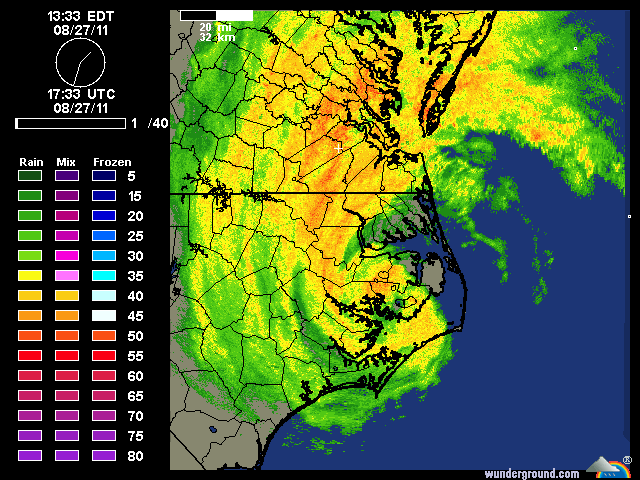
Enhanced Infrared Imagery of Hurricane Chris
The hurricane season thus far has proven to be an early bloomer. After recording our first two tropical cyclones of the season in May, the season has continued its early season by providing us with the third named system in June and our first named hurricane, which is much earlier than normal. For a comparison, Irene was the first named hurricane in the 2011 hurricane season, which occurred in late August! In any event, the origin of Chris can actually be traced back to a non-tropical low pressure that developed along a decaying frontal boundary. As the front continued to decay, an upper level potential vorticity (PV) maximum moved over the non-tropical low pressure, and quickly allowed the low pressure to occlude and undergo warm seclusion as it detached from the frontal boundary and became vertically stacked with the upper level disturbance. Deeper convection then began to form around the circulation as the temperature gradient between the marginal sea surface temperatures (SSTs) compared to the anomalously cold upper level temperatures was sufficient for deeper convection. At this point, the system had a decent warm core, and the National Hurricane Center (NHC) felt that the deep convection and overall more tropical nature of the storm was sufficient for an upgrade. Beyond this time, the system has only become better organized, with an eye feature developing on IR as early as last evening. The visible imagery this morning is particularly impressive with spiral bands and moderate deep convection surrounding the eye in all quadrants. Despite the current well organized appearance, the system is quickly moving towards colder waters even less supportive of a tropical cyclone, so its unlikely Chris will be able to continue to intensify as an tropical system. However, there is a 60-70 m/s jet streak located to the west of Chris which is aiding in divergent upper level flow on the left exit region of the jet streak. This will probably allow Chris to transform into a powerful extra-tropical cyclone as it moves over the cooler waters of the north Atlantic.
Gulf of Mexico Disturbance (Now Invest 96L)

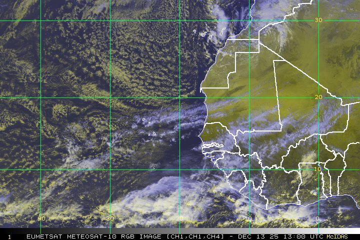
Visible Imagery of the Gulf of Mexico Disturbance
With Chris moving out of the picture, the next threat turns to something closer to home that is beginning to organize in the Gulf of Mexico. A very large circulation is developing in the Gulf of Mexico. Currently, we have a broad area of 850 hPa vorticity that is elongated from the Yucatan Peninsula up into the east Gulf of Mexico. This area of vorticity is associated with deep convection, although it is displaced somewhat to the south and east of the vorticity, which is obvious looking at the visible loop above. The convection is also associated with a developing upper level anticyclone, which is helping to ventilate the convection in the upper levels. The biggest questions in the coming days is what will this large broad circulation do, and who will be affected.

ECMWF Forecast for the large-scale circulation that develops over the Gulf of Mexico. Plotted are 500 hPa absolute vorticity (shaded) and geopotential heights (white contours). Annotated features are highlighted.
Animated above is the 00z ECMWF showing absolute vorticity and geopotential heights. I have highlighted the relevant features that will influence the development and track of this feature for the next 5 days. First, I want to draw your attention to the orange shaded areas of cyclonic vorticity. These represent the multiple mesovorticies that are rotating around the larger circulation that is centered over the Gulf of Mexico. While initially these areas of vorticity are small and diffuse, they start to merge over the Eastern Gulf of Mexico east of the mean low level circulation center by day 3. This type of circulation evolution is similar to how tropical cyclones develop in large gyre-like circulations that traditionally occur in the West Pacific Basin. For more reading on these types of cyclones, there are several good papers by Lander (1994) and Molinari and Vollaro (2012) that document the development and evolution of these types of systems. While the gyre circulation is relatively large, it moves very slowly for the first 3-4 days, as the upper level ridge attempts to develop eastward across the deep south in the wake of a weak trough. However, by the end of the forecast period, the upper level ridge gives way, and the westerly flow associated with a series of weak upper level troughs starts to pick up the developing tropical cyclones in the Eastern Gulf of Mexico. A word of caution. While this is one solution depicted from the ECMWF, the forecast genesis of a tropical cyclone (TCG) is still a big unknown. It all depends on which area of vorticity becomes the dominant feature and where these individual mesovorticies decide to merge. The spatial scale of most of the global models is simply too coarse to predict which convective elements will influence the development of this feature. The GFS provides a different solution, with vorticity becoming focused east of the Florida coastline rather than in the Gulf of Mexico. With the potential TCG of this event still a good 2-4 days away, there will probably be large jumps in the modeling, as the models get a better handle of the convective elements rotating around the larger circulation. At this point, there is no done deal that this system will evolve into a tropical cyclone, and I’m in support of the NHC’s outlook of a 30% chance of tropical cyclone development in the next 48 hours. I do think the chances for TCG do increase beyond that time frame, however. Given the broad nature of this disturbance, development will be very slow

GFS forecast at 54 hours with Standardized Anomalies of Precipitable Water (shaded) and 700 hPa winds (wind barbs)
One thing that is probably a safe bet though is torrential rainfall from the Yucatan coastline of Mexico across into Cuba and most of Florida. This circulation will be tapping into a precipitable water environment that is 3-5 standard deviations above average. This moisture originates from moisture originally drawn up from the intertropical convergence zone (ITCZ) that moved northward across Central America after the landfall of Hurricane Carlotta. Thus, while TCG may still be up for debate at this point, the threat for life-threatening flooding rainfall across the large area is a very real concern on the south and eastern regions of this large scale circulation. Even this morning, a sounding from Key West, FL (KKEY) showed total precipitable water at 2.43″ which is near its record value. This is very impressive considering how moist south Florida typically is this time of the year. This very deep and moist atmosphere will only continue to spread northward with time as the low level flow associated with the circulation continues to spread an influx of moisture from Central America northward.
Aside from these two features, there isn’t much else happing, and the East Pacific is quiet after Carlotta hit last week. I’ll keep you updated on the latest in the Gulf of Mexico, and until then enjoy the rest of your work week!


