Tropical Activity For August 19th, 2011
The tropics are once again starting to get busy. We have three systems worth talking about today. First is the recently upgraded Tropical Storm Harvey which might have a shot at further intensification over the next 24 hours before landfall in Belize . Next up is Invest 97L which is gradually getting better organized. Finally we have a third system, Invest 98L which looks like it might try to develop right off the coast of Africa. I’ll break down each system individual below.
Tropical Storm Harvey

Visible Loop of Tropical Storm Harvey
Invest 93L, the system we have been tracking for the better part of the last week finally attained enough of a circulation to be classified as a tropical cyclone late last night. Since then, the center relocated further northward, narrowly avoiding landfall in Honduras and has since organized further, as evidence of the increase banding on visible imagery above and and a developing central dense overcast (CDO). Morning microwave imagery showed evidence of this banding on the northern half of the center, although this was taken before the recent burst of convection closer to the center. Wind shear over the system continues to be very low as a upper level anticyclone continues to track alongside the system. These favorable upper level winds are also complimented by high total precipitable water (TPW), which is favorable for the continued maintenance of convection near the center. Another favorable factor is the very high sea surface temperatures under the circulation, exceeding 30 degrees Celsius in spots. This is witnessed alongside relatively high oceanic heat content. In essence all things are go for significant intensification for Harvey except one… land interaction. This will likely halt the intensification process beyond 24 hours as the system strikes the coastline of Belize. So how much can we expect Harvey to intensify in the mean time?

Forecast Track and Intensity For Tropical Storm Harvey
Pictured above is my first (and likely only) forecast for Tropical Storm Harvey. Trackwise, things are pretty straightforward, with the system continuing along on a west to west-northwest track until landfall somewhere along the coast of Belize. While most of the track guidance is tightly clustered, I support a track slightly further north than the mean consensus, mainly because I expect a slightly more vertically deep system that should be able to track just a tad further north while the mid-level ridge remains fairly week over the system. Post-landfall, however, I agree with most of the modeling that Harvey will turn back to the west, as the mid-level ridge strengthens while the system travels over Mexico. This will make it unlikely that Harvey will be able to re-emerge into the Bay of Campeche. The intensity of Harvey is a little bit more tricky, since the system is now expected to spend about 18-24 hours over very warm open waters. Its important to note that Harvey is a small than average tropical cyclone, which makes it more susceptible to favorable or unfavorable conditions. In this case, we had a couple of pretty good case studies to go by last year, Hurricanes Karl and Richard. Both systems were smaller than average and traversed very close to the same area that Harvey is currently located, while also experiencing favorable atmospheric conditions. Both systems intensified 25 knots in a 24 hour period leading up to their landfalls in Belize. Thus, given that Harvey is in the same region, also under favorable conditions, and has about 18-24 hours before landfall, I think its reasonable to expect a 20-25 knot increase in strength before the system makes landfall. Thus from the 11am position given by the NHC, I am forecasting landfall in about 27 hours very close to Belize City with a landfall intensity of 70 mph or 60 knots. This is about 10 knots higher than even the highest intensity guidance so I consider this a very bullish forecast. I’ll have a recap of Harvey and post my verification map after the storm has dissipated over Mexico.
Invest 97L

Visible Loop of Invest 97L
Next up on the list is Invest 97L. This system has been moving westward across the Atlantic while slowly but surely becoming better organized with time. While convective activity has increased in intensity over the northwestern side of the circulation, microwave imagery still shows this activity is poorly organized and only part of a much more broad circulation. Part of the reason why 97L has been taking such a long time to develop is the extensive amount of dry air that still surrounds the circulation in three quadrants. This dry air is rotating around the broad circulation and still suppressing convective development on south and southeasterly inflow side of the system. Some of this dry air is related back to the Saharan Air Layer (SAL) that still has a distinct presence around the storm. On the positive side for development, however, shear continues to remain low with a distinct anticyclone on top of the system. Sea Surface Temperatures (SSTs) have also begun to rise under the system, which should promote more convective development at the mid to upper level dry air finally wears off. Finally, over the past few days there has been a couple of decent kelvin waves, as represented by a cluster of lower outgoing longwave radiation (OLR) anomalies. These waves help to slow down the easterly trade winds near the surface, while also slowing down upper level westerly flow, in theory creating a low shear environment for a tropical system. The large scale divergence aloft also helps to invigorate convection. Thus, the presence of these kelvin waves over the Atlantic basin will likely aid in the development process of 97L at least for the next 24 hours before the kelvin wave moves eastward. Finally, there has been much model support indicating the future cyclogenesis of 97L. The GFS shows cyclogenesis as soon as 48 hours away as the system moves through the Lesser Antilles. The ECWMF which has been more on the conservative side with development, now is also in agreement with the GFS, showing tropical cyclogenesis occurring by 48 hours. Based on all of these signals above, I am now giving 97L a 60% chance of tropical cyclone development in the next 48 hours, emphasizing that it will likely occur towards the end of this period. If dry air hangs around longer than expected, it won’t surprise me to see this system take a little longer to get going. Of course the big question is that after cyclogenesis takes place, where will this track and how strong will it get?

Animation of Four Global Models at 120 hours (ECWMF, UKMET, GFS, GGEM)
The plot above shows four of the leading computer models out to 120 hours. Outlined above are also the 500mb features, including mid-level ridges and troughs. As you can see most of the models are showing this double barrel ridge pattern with a developing weakness by the East Coast of the United States. This makes the following track forecast beyond 120 hour rather tricky. At this time though, the models are actually showing remarkable consistency for a 5 day forecast with most of the global models placing Invest 97L in the Caribbean just to the west of Hispaniola. Beyond this period, it is going to be up to the strength of the mid-level ridging whether or not we see our feature start to turn further northwest over Cuba before affecting Florida, or continue a more westward track into the Gulf of Mexico. Thus far, the only model that seems to break down the 588dm ridge compleatly at 500mb is the ECWMF, showing a partial breakdown of the mid-level ridge directly north of the system. This is likely why the model starts to take the system much further northward thereafter. The rest of the models, however, do maintain some sort of ridging in place. Of additional note is the mid-level trough that will attempt to break down the ridge during this period. It is interesting the ECWMF has the most pronounced weakness, yet the trough is also located further north than the rest of the global models in this suite, perhaps indicating that the model might be prematurely weakening the ridge. The ECWMF ensembles in contrast show a much similar pattern to the other global models, keeping the 588dm ridge intact at 500mb. Looking at a couple of particular indexes, the southern oscillation index (SOI) over the past several days has averaged positive. This tends to signal that additional ridging is possible in the subtropics which could suggest that the models are underplaying the strength of the ridge. Thus, my very speculative thinking is that 97L has a better shot of verifying more on the western track suite than the eastern track suite at this time. Beyond 120 this could have pretty significant impacts to the forecast. In addition to track ideas, 97L intensity forecast is very much up in the air even beyond genesis. There is potential for a lot of land interaction with the Greater Antilles, including Hispaniola. I’d rather not speculate on how strong 97L could get, although the intensity guidance is very bullish, showing the potential for hurricane intensity to be attained if the system remains free of land interaction.
Overall, I can say with growing certainty that this system could be a threat to the United States Coastline thanks to the strong mid-level ridge north of the system. However, beyond this, it is still very speculative to suggest where this system might make landfall. Interests from Texas all the way east to the Carolina Coastline need to pay close attention to this system.
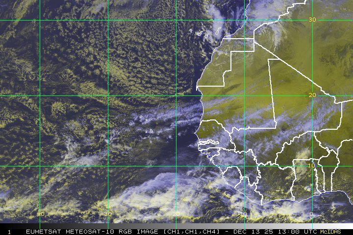
Invest 98L

Satellite Loop of Invest 93L
In addition to 97L in the Atlantic, we now have Invest 98L that has recently emerged off the African Coast. Currently you can see above that the system has a broad low level circulation with a couple of embedded small vorticies. Convection has been a little bit on the poultry side today, although more recently activity is starting to fire near the more northern circulation. Microwave imagery, though, shows that most of the convective activity is poorly organized at best. While the current upper level environment features an anticyclone over the system, which should favor development along with a kelvin wave currently progressing through the region, the broad disjointed nature of the system argues against rapid development. In addition, track guidance is showing that 98L will move northwest from the Cape Verde islands, which would place it in an area of SSTs that are below 27 degrees Celsius, which is marginal at best for further development. In addition, very dry air is located further to the northwest which will future inhibit convective formation. Thus the prospects for Invest 98L don’t look too good right now. While conditions are favorable now, development will be slowed by the fact the circulation is broad and elongated over two centers. Even after these two centers consolidate, the system will be moving out into a more unfavorable environment beyond 36 hours. Thus, I am going under the National Hurricane Centers forecast probability and only forecasting a 30% chance of tropical cyclone development in the next 48 hours. If this does occur it will likely occur in the next 24 hours before conditions become more hostile for development.
And phew… that’s all I have to talk about for today. The tropics are certainly getting busy, and I’ll have an update tomorrow on all the systems I’ve outlined today.