Tropical Activity For July 7th, 2011
Hello again as we progress through the latter half of this week. The tropics once again seem to be heating up a bit with two identifiable disturbances located in the Atlantic basin. One is the continuation of convection across the Caribbean although it has moved further west creating heavy tropical rains across Florida. The next area of disturbed weather is located further east and rather far south in the Atlantic basin. I’ll first focus on the area of convection closest to the United States.
Disturbance Over Cuba
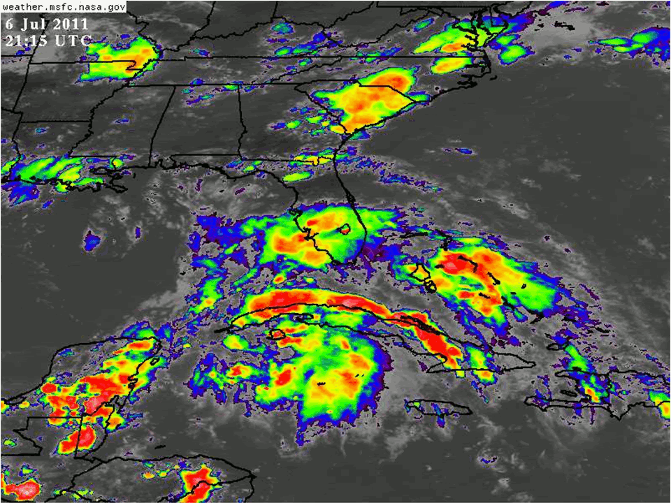
Tropical Disturbance over Cuba
The same disturbance that I mentioned earlier week has managed to persist, although not improve in organization, as it has drifted off to the west-northwest, with its axis resting somewhere near Cuba. While convection has maintained its intensity, most of this is due to the strong upper level low currently situated in the Gulf of Mexico, helping to generate ample divergence aloft which is aiding in convective growth. However, this has continued to shear the system, as the bulk of the best low level vorticity is located under 20-40 knots of wind shear. Looking over the next 24-48 hours, this upper level winds shear is expected to persist. This is why it is perplexing that the North American Model (NAM) wants to forecast a substantial increase in 850mb vorticity, even when the upper level wind flow continues to be from 20-40 knots over this potential vortex. The Global Forecasting System (GFS) shows a much more realistic solution with only weak vorticity persisting in the face of 20-30 knot upper level westerly wind flow. In anything, it seems that this disturbance greatest impact will the the ample moisture it will bring from tropical origins to the Eastern Seaboard with widespread showers and thunderstorms, likely causing localized flash flooding. From a development standpoint though, this system is not likely to become a tropical system, and I remain steadfast with my outlook that this has no chance of development in the next 48 hours.
Tropical Wave in Deep Atlantic
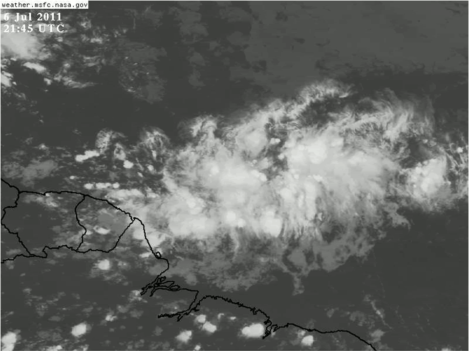
Tropical Wave in the Atlantic Ocean
The next feature to discuss in the Atlantic basin is a low latitude tropical wave that is moving along quite briskly in the central Atlantic. From the inferred image above, you can already see this feature has ample convection with expanding outflow both pole-ward and equator-ward. This outward expanding outflow shows up really well with the upper level satellite derived winds. This outflow is also helping to aid in the upper level divergence over the convection currently. Much of this deep convection is also being fed by warm sea surface temperatures (SSTs) around 28-29 degrees Celsius. In addition, the storm is currently located in a low shear environment around 5-10 knots. However, 850mb vorticity is still lacking currently over the tropical wave, with only a small patch located over the deep convection. So with all of these factors in place, what does the future look like for this wave in the central Atlantic.

As the wave continues to move generally westward, a building anticyclone should provide a favorable environment for organization, although it remains to be seen if it has enough time to become a tropical cyclone.
Looking first at the forecast from the GFS, there are a few features worth taking note. First of all, the GFS is very bullish with this tropical wave, increasing vorticity substantially that by the time the feature reaches the Lesser Antilles, it is already near depression threshold. this can be seen as evidence of the 30+ knot winds on the NW side of the circulation by 39 hours as the system moves across the Lesser Antilles. It does appear as seen in the loop above that the wave will be under a very favorable environment characterized by strong divergence and expanding upper level outflow to the west. In addition to the bullish GFS, the Canadian Model (CMC, GGEM) shows a very similar area of strong vorticity near the Lesser Antillies in 36 hours. The Euro (ECWMF) on the other hand, shows a much weaker vorticity signal at 48 hours. Given the current satellite presentation, I am inclined to believe the more bullish guidance. Still though, the fast forward motion may make it difficult to close off a surface circulation even as the low level vorticity increases. In addition, if this system does not gain enough latitude in the next 36 hours, it may be destined to make landfall in the South American coastline, before it has the chance to become a tropical cyclone. Based off all of the factors above, I am giving this a 30% chance of tropical cyclone formation in the next 48 hours. Even if this system does not become a tropical cyclone within this time frame, there are hints in the modeling that the vorticity may go on to help invigorate the semi-permanent low in the Southern Caribbean, which may help to induce tropical cyclogenesis later on in the Western Caribbean or Gulf of Mexico. Support for this later genesis can be found in the expectation that the MJO will become active in phase 1, supporting increased divergence aloft over the West Atlantic Basin.
Beyond these features, there really isn’t much else in the Atlantic. There is another batch of convection located out along the Lesser Antillies currently, but this is mainly just divergence induced convection from an tropical upper tropospheric trough (TUTT) which will eventually shift northward as the building upper level ridge takes its place.
That’s all I have for today. Until next time!